23 Utah
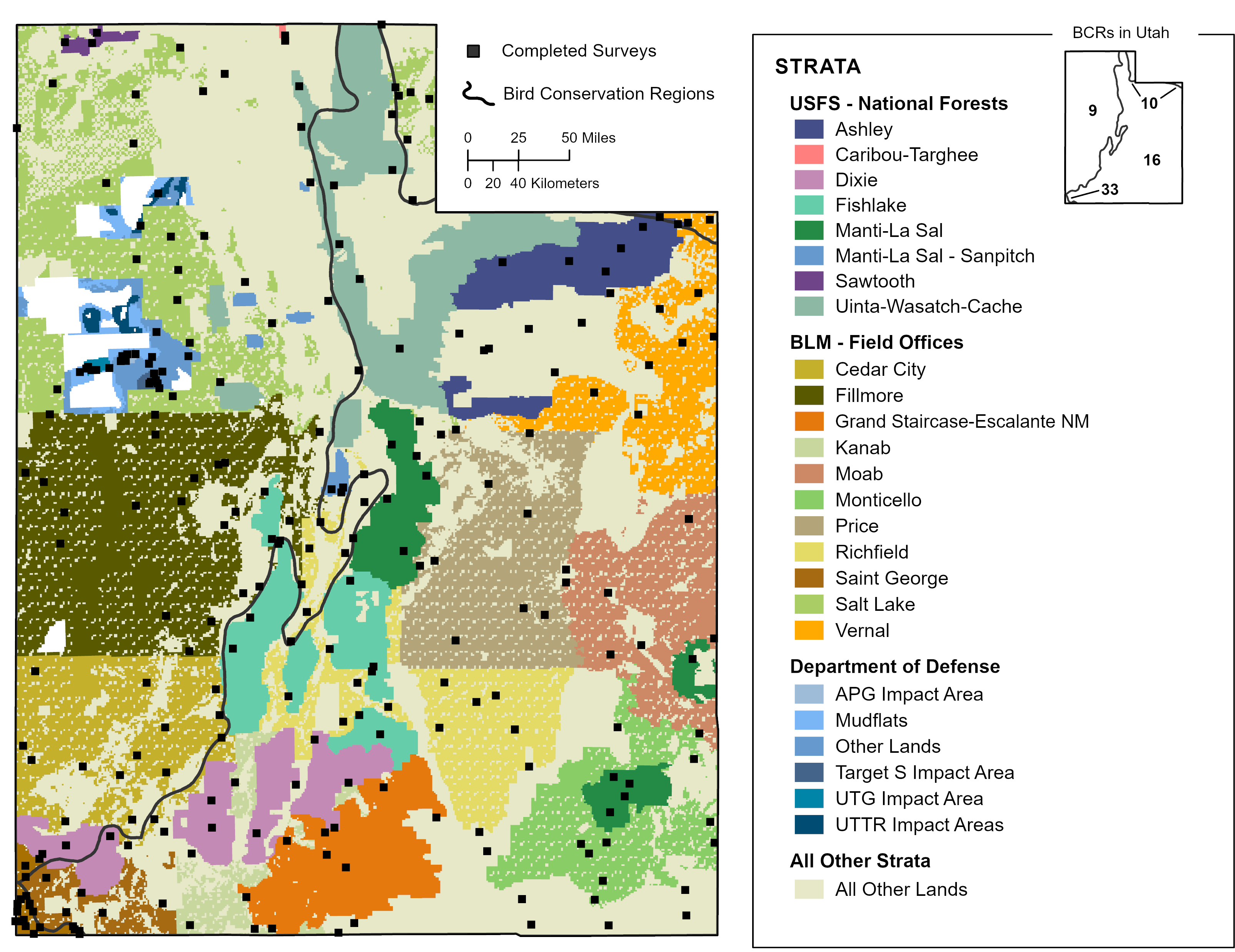
In 2025, we had complete survey coverage across the state of Utah (Figure 23.1).
23.1 Utah Statewide: Total
Utah Statewide: Total
We obtained results for Utah Statewide: Total by compiling and jointly analyzing data from 42 strata.
Field technicians completed all planned surveys (100%) in 2025. Technicians conducted 2904 point counts within the 256 surveyed grid cells between May 9 and July 10. They detected 180 bird species, including 9 priority species.
Bird Conservancy estimated densities (birds per square kilometer) for 224 species that were detected in any year during which surveys were conducted, 14 of which are priority species. The data yielded robust density estimates (CV < 50%) for 101 species.
Bird Conservancy estimated the proportion of occupied plots throughout Utah Statewide: Total for 222 species that were detected in any year during which surveys were conducted, 14 of which are priority species. The data yielded robust occupancy estimates (CV < 50%) for 117 species.
23.2 All Other Lands in Utah
All Other Lands in Utah
We obtained results for All Other Lands in Utah by compiling and jointly analyzing data from four strata.
Field technicians completed 91 of 93 planned surveys (98%) in 2025. Technicians conducted 1081 point counts within the 91 surveyed grid cells between May 9 and July 10. They detected 162 bird species, including 8 priority species.
Bird Conservancy estimated densities (birds per square kilometer) for 203 species that were detected in any year during which surveys were conducted, 12 of which are priority species. The data yielded robust density estimates (CV < 50%) for 62 species.
Bird Conservancy estimated the proportion of occupied plots throughout All Other Lands in Utah for 202 species that were detected in any year during which surveys were conducted, 12 of which are priority species. The data yielded robust occupancy estimates (CV < 50%) for 70 species.
23.3 Utah BCR 10: Total
Utah BCR 10: Total
We obtained results for Utah BCR 10: Total by compiling and jointly analyzing data from five strata.
Field technicians completed 11 of 14 planned surveys (79%) in 2025. Technicians conducted 111 point counts within the 11 surveyed grid cells between June 19 and July 6. They detected 64 bird species, including 3 priority species.
Bird Conservancy estimated densities (birds per square kilometer) for 141 species that were detected in any year during which surveys were conducted, 8 of which are priority species. The data yielded robust density estimates (CV < 50%) for 10 species.
Bird Conservancy estimated the proportion of occupied plots throughout Utah BCR 10: Total for 141 species that were detected in any year during which surveys were conducted, 8 of which are priority species. The data yielded robust occupancy estimates (CV < 50%) for 10 species.
All Other Lands in Utah BCR 10
We obtained results for All Other Lands in Utah BCR 10 by compiling and analyzing data from one stratum.
Field technicians completed 2 of 5 planned surveys (40%) in 2025. Technicians conducted 13 point counts within the 2 surveyed grid cells between June 20 and June 30. They detected 18 bird species, including 2 priority species.
Bird Conservancy estimated densities (birds per square kilometer) for 92 species that were detected in any year during which surveys were conducted, 4 of which are priority species. The data yielded robust density estimates (CV < 50%) for 0 species.
Bird Conservancy estimated the proportion of occupied plots throughout All Other Lands in Utah BCR 10 for 92 species that were detected in any year during which surveys were conducted, 4 of which are priority species. The data yielded robust occupancy estimates (CV < 50%) for 3 species.
23.4 Utah BCR 16: Total
Utah BCR 16: Total
We obtained results for Utah BCR 16: Total by compiling and jointly analyzing data from 18 strata.
Field technicians completed 126 of 122 planned surveys (103%) in 2025. Technicians conducted 1375 point counts within the 126 surveyed grid cells between May 9 and July 10. They detected 149 bird species, including 4 priority species.
Bird Conservancy estimated densities (birds per square kilometer) for 196 species that were detected in any year during which surveys were conducted, 10 of which are priority species. The data yielded robust density estimates (CV < 50%) for 87 species.
Bird Conservancy estimated the proportion of occupied plots throughout Utah BCR 16: Total for 195 species that were detected in any year during which surveys were conducted, 10 of which are priority species. The data yielded robust occupancy estimates (CV < 50%) for 93 species.
All Other Lands in Utah BCR 16
We obtained results for All Other Lands in Utah BCR 16 by compiling and analyzing data from one stratum.
Field technicians completed 41 of 39 planned surveys (105%) in 2025. Technicians conducted 473 point counts within the 41 surveyed grid cells between May 9 and July 10. They detected 130 bird species, including 3 priority species.
Bird Conservancy estimated densities (birds per square kilometer) for 167 species that were detected in any year during which surveys were conducted, 9 of which are priority species. The data yielded robust density estimates (CV < 50%) for 36 species.
Bird Conservancy estimated the proportion of occupied plots throughout All Other Lands in Utah BCR 16 for 168 species that were detected in any year during which surveys were conducted, 9 of which are priority species. The data yielded robust occupancy estimates (CV < 50%) for 43 species.
23.5 Utah BCR 33: Total
Utah BCR 33: Total
We obtained results for Utah BCR 33: Total by compiling and jointly analyzing data from two strata.
Field technicians completed all planned surveys (100%) in 2025. Technicians conducted 196 point counts within the 16 surveyed grid cells between May 9 and May 22. They detected 77 bird species, including 2 priority species.
Bird Conservancy estimated densities (birds per square kilometer) for 122 species that were detected in any year during which surveys were conducted, 4 of which are priority species. The data yielded robust density estimates (CV < 50%) for 5 species.
Bird Conservancy estimated the proportion of occupied plots throughout Utah BCR 33: Total for 121 species that were detected in any year during which surveys were conducted, 4 of which are priority species. The data yielded robust occupancy estimates (CV < 50%) for 3 species.
All Other Lands in Utah BCR 33
We obtained results for All Other Lands in Utah BCR 33 by compiling and analyzing data from one stratum.
Field technicians completed all planned surveys (100%) in 2025. Technicians conducted 167 point counts within the 13 surveyed grid cells between May 13 and May 22. They detected 69 bird species, including 2 priority species.
Bird Conservancy estimated densities (birds per square kilometer) for 116 species that were detected in any year during which surveys were conducted, 1 of which are priority species. The data yielded robust density estimates (CV < 50%) for 8 species.
Bird Conservancy estimated the proportion of occupied plots throughout All Other Lands in Utah BCR 33 for 117 species that were detected in any year during which surveys were conducted, 1 of which are priority species. The data yielded robust occupancy estimates (CV < 50%) for 8 species.
23.6 Utah BCR 9: Total
Utah BCR 9: Total
We obtained results for Utah BCR 9: Total by compiling and jointly analyzing data from 17 strata.
Field technicians completed 103 of 104 planned surveys (99%) in 2025. Technicians conducted 1222 point counts within the 103 surveyed grid cells between May 11 and July 9. They detected 133 bird species, including 6 priority species.
Bird Conservancy estimated densities (birds per square kilometer) for 176 species that were detected in any year during which surveys were conducted, 12 of which are priority species. The data yielded robust density estimates (CV < 50%) for 56 species.
Bird Conservancy estimated the proportion of occupied plots throughout Utah BCR 9: Total for 176 species that were detected in any year during which surveys were conducted, 12 of which are priority species. The data yielded robust occupancy estimates (CV < 50%) for 60 species.
All Other Lands in Utah BCR 9
We obtained results for All Other Lands in Utah BCR 9 by compiling and analyzing data from one stratum.
Field technicians completed 35 of 36 planned surveys (97%) in 2025. Technicians conducted 428 point counts within the 35 surveyed grid cells between May 12 and July 9. They detected 115 bird species, including 5 priority species.
Bird Conservancy estimated densities (birds per square kilometer) for 147 species that were detected in any year during which surveys were conducted, 8 of which are priority species. The data yielded robust density estimates (CV < 50%) for 31 species.
Bird Conservancy estimated the proportion of occupied plots throughout All Other Lands in Utah BCR 9 for 147 species that were detected in any year during which surveys were conducted, 8 of which are priority species. The data yielded robust occupancy estimates (CV < 50%) for 31 species.